|

Drass Valley
The Dras Vall ey
is an enchanting valley formed by the Dras River which rises in
the Machoi glacier near the famous Zozila Pass. The river is
joined in its course by many other rivers and streams flowing in
from snowfields in the nearby mountains. ey
is an enchanting valley formed by the Dras River which rises in
the Machoi glacier near the famous Zozila Pass. The river is
joined in its course by many other rivers and streams flowing in
from snowfields in the nearby mountains.
Drass
(3230 m), 60 km west of Kargil on the road to Srinagar, is a small
township lying in the centre of the valley of the same name. It
has become famous as the second coldest inhabited place in the
world by virtue of the intense cold that descends upon the valley
along with repeated snowfalls during winters. Winter temperature
is sometimes known to plummet to less than minus 40 degrees.
The Drass valley starts from the base of the Zojila pass, the
Himalayan gateway to Ladakh. For centuries its inhabitants are
known to have negotiated this formidable pass even during the most
risky period in the late autumn or early spring, when the whole
sector remains snow-bound and is subject to frequent snow storms,
to transport trader's merchandise across and to help stranded
travellers to traverse it. By virtue of their mastery over the
pass they had established a monopoly over the carrying trade
during the heydays of the Pan-Asian trade. A hardly people
enduring with fortitude and harshness of the valley's winter, the
inhabitants of drass can well be described as the guardian's of
Ladakh's gateway
THE CASTLE OF SANI
Not only in Sani a particularly sacred place due to its having
been visited and blessed by Padmasambhava of Oddhiyana but it is
also prophesied to be equal and importance to the cemetery of
Dechendal in India. There can be seen a cemetery ground with
cemetery trees an d cemetery springs and also a footprint of Guru Nima Odzer. In the centre of the rockface on the opposite side of
the River there can be seen a meditation cave and a footprint. It
is said that the Guru stayed there practicing meditation for many
years. In Sani is also the great Stupa of Kanishka founded in 124
AD. By king Kanishka and the sacred of Naropa which can be seen on
the day of the pilgrimage to Sani which occurs in the 6th Tibetan
month. Within the castle there can be seen the various and most
beautiful wall paintings which were executed by Zadpa Dorje. d cemetery springs and also a footprint of Guru Nima Odzer. In the centre of the rockface on the opposite side of
the River there can be seen a meditation cave and a footprint. It
is said that the Guru stayed there practicing meditation for many
years. In Sani is also the great Stupa of Kanishka founded in 124
AD. By king Kanishka and the sacred of Naropa which can be seen on
the day of the pilgrimage to Sani which occurs in the 6th Tibetan
month. Within the castle there can be seen the various and most
beautiful wall paintings which were executed by Zadpa Dorje.
New Areas
Government of India, Ministry of home Affairs has recently
declared some more a areas of Ladakh opened for International
Tourism. These areas are among the outstanding feature of
Himalayan Panorama. It could be yet another destination for the
global tourists. These areas are relatively more distinct for
cultural and adventure tourism. While declaring the new areas of
Khaltse, Nubra & Nyomo Sub-Division, Govt. of India however
restricted the movement of traffic flow on 7 different tour
circuits to these divisions. Minimum period required for visiting
these areas should not exceed 7 days. To understand, these
circuits are set here in sequence and those are outlined and
separately explained here.
Khaltse Sub-Division (Drokhpa Area).
Khaltsi-Dumkhar-Skurbuchan-Hanudo-Bima-Dha
NUBRA SUB-DIVISION
Leh-Khardongla-Khalsar-Tirit upto Panamik
Leh-Khardongla-Khalsar-Hunder.
Leh-Saboo-Degarla-Degar-Labab-Khungru Gonpa-Tangyar
(only for trekking accompanied by state police)
NYOMA SUB-DIVISION.
Leh-Upshi-Depring-Puga-Tsomoriri Lake-Korzok
Leh-Upshi-Puga-Tsomoriri Lake-Korzok.
Leh-Karu-Changla-Durbuk-Tangtse-Lukhung-Spangmik.
It will be obligatory on the part of Tourists, tour operators and
other agencies related with the organised tour that the tourists
travel on the identified tour circuits only. They should strictly
follow the dos and don’ts as laid down by the Government.
DROGPAS
Drogpa areas have been outlined in the Tour Circuits. Out of 5
Drogpa villages in India two are open for foreign tourists. The
greatest attraction in these areas are the villages of Dha and
Biama which are entirely populated by last remaining remnants of
the Dards in the District.Dards are considered as last race of
Aryans confined to Indus Valley. These villages have considerable
anthropological and ethnographic importance. Festivals of those
villages are called harvest festivals. These are considered rare
and eventful the year of Drogpa in which all the people of these
villages come out of their colourful traditional dress and
festival moods to celebrate the festivals. Preceding to the
Drogpas villages the village which fall enroute are the villages
of Domkhar Skurbuchan, Achinathang which are also important and
which tourists can also easily visit. At this stage, tourism being
like new-born baby, infrastructures are not adequate in this area.
However there is a very good road leading right upto Drogpa
villages and tourist can stay over nights in some private guest
houses and or at some identified camping site at Khaltsi, Dhomkhar,
Skurbuchan, Achinathang, Hanu Do, Biama and Dha village.
Approximately distance between Leh and Drogpas villages are
between the range of 150 to 170 kms from Leh.
NUBRA VALLEY
This valley is popularly known as Ldomra or the valley of flowers.
It is situated in the North of Ladakh, between Karakoram and
Ladakh ranges of Himalayas. Nubra lies at average altitude about
10,000 feet above sea level. The climate, of the areas being soft,
soil is much fertile and the vegetation of the area is
comparatively thicker than those of the other areas of Ladakh.
Shrubs, bushes and trees grow in abundance wherever there is any
source of water. Due to this reason Nubra has acquired its right
name- Ldomra. Shayok river Siachan River forms largely drain Nubra
its single largest tributary. Nubra is a broad valley with lofty
mountains on its all sides. Valley assumes greater attractions at
the site where both the rivers meet. The formation of Central part
of Nubra also takes place there. Diskit is the Sub-Division HQ. Of
Nubra. Diskit Gonpa is also situated at a height of about 200 mtrs.
Above the village, on the spur of rocky mountain and at the most
commanding point having clear view of the entire central part of
Nubra. Samstanling Gonpa is situated on the North facing Diskit
Gonpa. This Gonpa is equally important and recreationally it
assumes greater importance for being situated at a commanding
scenic view point at the foot hills of Karakoram ranges up above
Tegar and Sumoor village, amidst plenty of water and high
vegetation. Major village via Kardong, Khalsar, Tirit, Sumoor,
Tegar Pinchemik, Titisha and Panamik all fall along the
traditional silk route. The caravans travelling Central Asia and
Kashmir through Nubra valley used to stay at those villages.
Panamik was the most important place for haltage of Caravan. It
served as last major village where the Caravans landed the
facility of feed back, before they negotiated Saser and Karakoram
pass towards Central Asia. The famous hot spring of Panamik also
served them as a source for bath, drinking water and medicine
purpose. Panamik has still got charms and potentiality to serve as
a host to travellers. All areas around it including Iantsa Gonpa
and Murgi waterfall across it combined with scenic view
strengthens its beauty and hospitality.
PLACES OF TOURIST INTEREST
Major attraction of Nubra is the highest motorable Khardongla pass
(18,383ft.) majestic peaks and glaciers enchanting valleys and
villages. Diskit and Samstanling Gonpa, Panamik hot spring, double
hump camel safari, river rafting, trekking and Sunbathe at Hunder
are also a great source of attraction for the tourists.
FACILITIES AVAILABLE
There is a well-maintained road to Nubra from Leh. Tourist can
avail the facility of P.W.D. Rest House at Khardong, Khalsar,
Diskit, Sumoor and Panamik villages. There are private guesthouses
and Tented camps (Identified as cam ping sites) at Khalsar,
Khardong, Diskit, Hunder, Tisrit, Sumoor Tegar, Tirisha and
Panamik. Besides there are shops and small restaurants/tea stall
at places enroute to Nubra valley. Some Hotels are also coming up
at Diskit, Hunder, Tegar and Panamik. There is road head right up
to Panamik and Hunder. Though the state of road stretch between
sought Pule and North Pulu is rough yet travelling and passing
through world highest motorable bus Khardongla (18,383 ft.) is the
most exciting part of journey to Nubra.
CHANGTHANG (NYOMA DIVISION)
The upland plateaus of Changthang in Nyoma Sub-Division are
possibly the most attractive areas in the District as far as
scenic beauty, brackish lakes and Wild Life are concerned. The
vast pastures with their gently flowing streams and the lakes
amidst the spectacularly coloured mountains are quite unlike
any-thing a tourist see anywhere in India.
PANGONGLAKE
This lake is situated at a elevation of 14,0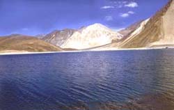 00ft. In the Eastern
sector of Ladakh, at a distance of 154km.from Leh across Changla
pass (17,000ft.).This lake is one of the largest and most
beautiful natural brakish lakes in the country. 00ft. In the Eastern
sector of Ladakh, at a distance of 154km.from Leh across Changla
pass (17,000ft.).This lake is one of the largest and most
beautiful natural brakish lakes in the country.
TSOMO RIRI LAKE
This lake is situated at a elevation of 15,000 ft. above the sea
level, at a distance of 240 kms. From Leh in the south-east sector
of Ladakh. It is like a pearl shape and contains large mineral
deposits. Korzok village is situated on the South West Bank of
this lake. Korzok Gonpa and its inhabitants the nomads (Changpas)
are most outstanding features of this lake.
WILD LIFE
Changthang also has an abundance of exotic Wildlife, Skyang, the
Tibetan wild ass and snow leopard are found here. Wild asses are
generally found grazing near Tsokar pastures and they seen moving
in flocks. Rare and exotic birds like Bar Headed Goose, the
migratory brids black Necked rare, the Great crested Grebe, the
Tibetan crane and the Brahme Ducks are also found in Changthang.
FACILITIES AVAILABLE
Tourist can avail the facility of PWD rest house at Tangtse
Chumathang, Korzok and Tourist Bungalow at Rumtse. There is
private guesthouse and tented camps (identified as camping sites)
at Durbuk, Tangtse, Muglab, Lukhung and Spangmik villages in the
Pangong Lake area. There is road head right upto the lake. It is
all metalled except the Changla pass and a stretch of 28 kms. From
between Tangtse and Lukhung which is rough.
There are tented camps at Chumathang and Korzok. Campsites are
also available at Skidmang, Tsokar, and Hemya. For the initial
state there are two different approach, which both are given in
the tour circuits 5&6 of Nyoma Sub-Division-one is from Leh-Manali
road via Polo Kongka pass (13,500 ft) and other is from Leh Nyoma
road which diverts at Mahey bridge. Both these roads meet at Sumda
in the Puga valley. From Sumda onwards to Tsomoriri, there is a
joint approach which is spread over a rough stretch of 43 Kms.
Besides this the initial approach of 57 Kms. between Sumda and
Manali road is also rough.
<<Back
Page |